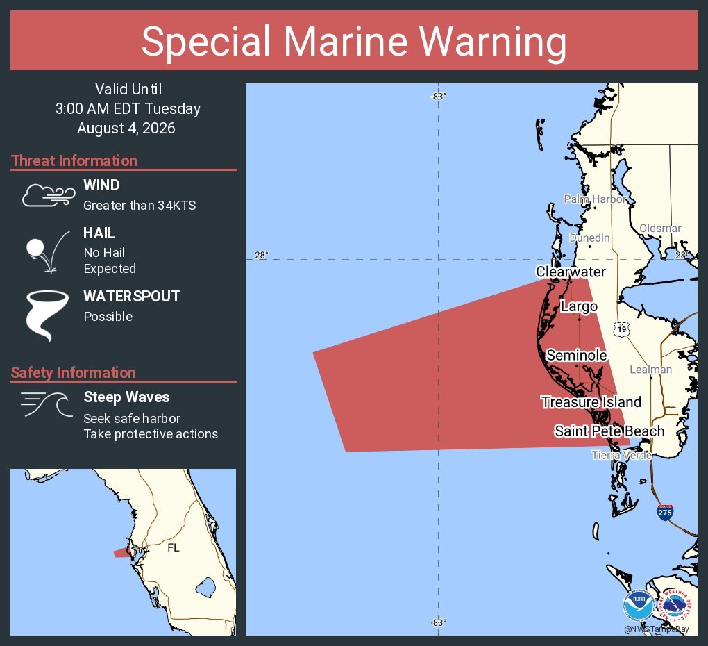
The National Weather Service in Ruskin issued a Special Marine Warning early Tuesday, Aug. 4, covering all of Tampa Bay, including waters off Apollo Beach and Ruskin, with possible waterspouts and wind gusts exceeding 34 knots through 3 a.m. Wednesday, Aug. 5.
It's the latest in a string of at least six such warnings the NWS Tampa Bay office has posted since Saturday, Aug. 1, an unusually active stretch that has kept local boaters on alert during peak summer season.
Tuesday's warning marks an escalation. Earlier alerts this week cited only wind gusts and steep waves; this one adds waterspouts as a threat for the first time.
What the warning means
A Special Marine Warning is the water equivalent of a Severe Thunderstorm Warning. It means the hazard is occurring or imminent, according to NWS marine safety guidance. Wind gusts of 34 knots (39 mph) or more can capsize small boats, and waterspouts can behave like tornadoes over open water.
The NWS advises boaters who encounter a waterspout to move at a 90-degree angle to its apparent path and never approach it.
Four days of warnings
On Saturday, Aug. 1, NWS Tampa Bay issued a warning for coastal waters and Tampa Bay. On Sunday, Aug. 2, two separate warnings hit with gusts exceeding 40 knots. Monday, Aug. 3, brought another alert covering offshore waters out to 60 nautical miles, effective until 9 a.m.
Then came Tuesday's overnight warning, issued around 2 a.m. and running until 3 a.m. Wednesday.
What's driving the storms
The NWS Tampa Bay coastal waters forecast issued at 9:34 a.m. Tuesday points to high pressure south of the region pushing a southwest-to-west flow over the Gulf, producing scattered to numerous showers and thunderstorms with gusty winds and choppy seas.
Conditions may ease slightly by midweek as high pressure builds over the area, but the seven-day forecast shows renewed thunderstorm activity Thursday through Saturday, Aug. 8, with east winds building to 10–15 knots.
How to stay safe
NWS guidance for boaters heading out this week:
- Check the marine forecast before every departure on NOAA Weather Radio or at weather.gov/marine.
- File a float plan at your marina.
- Carry a VHF marine band radio and monitor Channel 16 for Coast Guard rebroadcasts of warnings.
- Ensure everyone aboard wears a life jacket when thunderstorms threaten.
- Know the limitations of your vessel in steep seas.
West-central Florida near Tampa has the highest frequency of thunderstorm days per year in the United States, according to the NWS. That makes summer the most dangerous season for boaters on the bay.
Boaters should check forecasts at least four times daily through the weekend.




.jpg)